| Regional Highway 1 | |
| Crowfoot Expressway Maintained by Transport Gravenhurst | |
| Length: | 47 km (29 mi) |
|---|---|
| Formed: | 1974 |
| East end: | |
| Beltway around Archemedes | |
| Major junctions: |
|
| West end: | |
| Autonomous Country: | Gravenhurst |
| Major cities: | Airborn - Oppel Donsley (Welford) Archemedes Borden |


Road sign on Highway 1 at peak width near its interchange with Highway 2.

Road sign on Highway 1 near its west-end.
Highway 1 (Traditional Chinese: 國道1號) is an at-grade highway that stretches from South Borden to Airborn - Oppel in Gravenhurst Region. The highway stretches for approximately 50 km. There are plans to lengthen Highway 1 by establishing a concurrence with the future Highway 510, which will extend Highway 1 to service southern communities such as Millenium Point.
Highway 1 begins at Gravenhurst Regional Road 10 (Browns Line), stretches east through the River Thames Expressway, through Welford, and finally reaching Oppel. At the current terminus of Highway 510, the portion of Highway 1 east of this point is named as Highway 1A.
The section between River Parkway and Toronto Avenue has been designated as Crowfoot Expressway, but this signage does not appear on road signs along the highway during this section.
Highway 1 is part of the Archemedes Ring Highway.
History[]
Prior to 1974, motorists who wish to travel from South Borden to Airborn - Oppel would have to rely on the former Highway 11, now the London Line. In the 1960s, traffic congestion was very common in the Downtown Avenue, or commonly referred to as the 505 / 506 Corridor, as thorough traffic in Archemedes would have to rely on this corridor to get to the other side of the town. Similar problems were also happening on Highway 11, but widening is not very possible in parts of the highway due to land dispute.
In 1969, the regional government discussed the possibility of building a two-stage ring road for the city of Archemedes to solve the traffic problem along the 505 / 506 Corridor. As a result, the Linc (Lincoln M. Alexander Expressway) was built in the 1970s as the first-stage. At the same time, a rough 2-lane undivided highway was set aside just north of Crowfoot, for the future, second-stage ring road. It was stretched from South Borden, through Crowfoot, Welford, and finally reaching just outside of Skybreaker. The highway was regarded as a preliminary boundary for the metropolitan area of Archemedes. This highway, in 1974, was signed as Regional Highway 1.
Due to Highway 1 had similar alignment as Highway 11, just about 6 km north of Highway 1, Highway 11 became a less favourite route for thorough traffic, and more for urban and local traffic. This eventually led to a downgrade of Highway 11. In 1982, a majority of Highway 11 east of Highway 10 was downloaded to the regional government.
Through years of development, Highway 1 widened through several sections. In 2001, in the midst of rapid urban expansion in South Archemedes, portions of Highway 1 from Toronto Avenue and River Parkway was expanded to a expressway.
Future Prospects[]
Highway 1 is regarded as a highway with many potentials. In the near future, it's entire length up to Highway 510 will be made into a six-lane expressway, serving as the second-stage ring road around the metropolitan area of Archemedes. Such work is expected to be completed by late 2010.
Lane Configuration[]
From west to east:
| Section | Travel lanes and description | Speed Limit (km/h) |
|---|---|---|
| Browns Line to west of Gravenhurst Regional Road 88 (Toronto Av.) | 1 lane in each direction, At-Grade Highway | 60 |
| Toronto Av. to River Thames Expressway (RTE) | 2 lanes in each direction, expressway | 80 |
| River Thames Expressway to Gravenhurst Regional Road 3 (McCallister Av.) | 3 lanes in each direction, expressway | 90 |
| McCallister Av. to Gravenhurst Regional Road 8 (River Parkway) | 2 lanes in each direction, expressway | 80 |
| River Parkway to Highway 510 | 2 lanes in each direction, right-in/right-out (RIRO) highway | 70 |
| Highway 510 to County Road 47 | 2 lanes in each direction, urban road | 60 |
Exit Number[]
From west to east:
| Exit Number (Eastbound) | Exit Number (Westbound) | Destination | Serving |
|---|---|---|---|
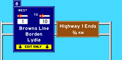
| N/A | 8 | Browns Line | Borden Lydia |
| 1 | 7A / 7B | Toronto Av. Industrial Av. S (Westbound Only) |
S. Archemedes |
| 2A / 2B | 6A / 6B | River Thames Expressway | Archimedes the Great International Airport Archemedes Downtown |
| 3 | N/A | South Central Parkway | |
| 4 | 5 |
Gravenhurst Regional Road 1 (Main St. S) |
S. Archemedes Archemedes Downtown |
| 5 | 4 | McCallister Av. | S. Archemedes |
| 6 | 3 | River Parkway | South Donsley (Perth) |
| 7A / 7B | 2A / 2B | Highway 3 | Welford Donsley |
| 8 | N/A | Community Drive | Welford |
| 9 | 1 | Line 40 (Cayuga Line) | Airborn |
| 10 | N/A | Highway 510 | Lisi |
Route Description[]
Browns Line to Toronto Avenue[]


Highway 1 westbound narrowing down to 1 lane
Highway 1 begins at Highway 10, locally known as Browns Line, off a traffic light in the central business district of South Borden as a two-lane road. Highway 1 continues to travel through farmlands in the locale as a one lane road, with speed limit only about 60 km/h. The section is considered an at-grade highway, as maintained by the regional government. The highway has an overpass through City Line Road, and thus officially enters into the boundary of Archemedes. Shortly after, right before Toronto Avenue, Highway 1 widens into three lanes per direction, one of which exits to Toronto Avenue. Here, the annual average daily traffic (AADT) is around 11,260.
Toronto Avenue to River Parkway[]


Highway 1 at Highway 3 near Welford.
As soon as the highway passes through Toronto Avenue, the road widens into two lanes, and into three lanes per direction after River Thames Expressway (RTE). The speed limit is also raised to 90 km/h. This section is considered as a freeway, and is the busiest section out of the road. For eastbound, there are exits to South Central Parkway, Main Street, McCallister Avenue, and River Parkway. Westbound exits are the same, except without South Central Parkway. Note that River Parkway and South Central Parkway exits are partial exits.
By McCallister Avenue, the right lane out of the three lanes available will be needed to exit. Motorists are advised to stay left for thorough traffic.
The AADT in this section is around 33,596.
River Parkway to Highway 510[]


Highway 1's east-end. Road sign showing junction between Highways 1, 1A, and 510.
After passing through River Parkway, the divider between the two side of traffic of the highway narrows, and eventually disappear, allowing Highway 1 to become a 4-lane undivided expressway. The highway travels through the rural area and farmlands of the southern parts of Donsley. The section is traffic light-less until when the Highway reaches Welford, near the Intersection with Highway 3. Immediately east of there, there are various underpasses and overpasses for local roads in Welford. Past beyond this point, the highway is a right-in, right-out (RIRO) expressway, while still remaining two lanes. The highway then moves through more farmland, and finally into the Skybreaker area. The highway eventually widens into four lanes, providing two for access to future Highway 510, and two to continue onto Highway 1A, or locally known as Oppel Street, an urban thoroughfare in Downtown Oppel.
The AADT in this section is about 18,218.
| 1 • 1A • 2 • 3 • 4 • 5 • 7 • 9 • 10 • 11 • 12 • 12A • 12B • 15 • 18 • 22 • 40 • 47 • 110 • 519 | |
| Airport (AE) • Happy Valley (HVE) • Jones Creek (JCE) • Lethbridge - Puffleton (LP) • Lincoln • Peace River (PRE) • River Thames (RTE) • Sussex - Valleydale (SVR) • Vandehogan (TVR) • W.R. Allen | |
| 505 • 506 • 511 • 512 • 519 | |
| 47 • 100 • 2006 | |
| Manhatten • Perimeter • 6 • 500 • 503 • 507 • 509 • 510 • 515 • 519 | |